|
It is always very clear over the first day or two of an exploration program which individual is the most important member of the team. The learning curve is very steep for all 5 of us Canadians here. None of us speak more than a few words of Bangla. We do not have enough knowledge of the Bengali script to differentiate between the sign for a maternal health center and a tire repair shop. As we pull our cables through cities of plastic sheeting and mud, we have to constantly be aware that these are people`s homes; though, we do not have the cultural or language skills to properly excuse ourselves or ask for permission to pass
0 Comments
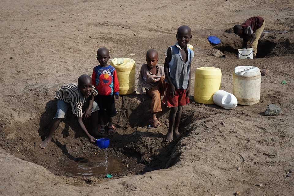
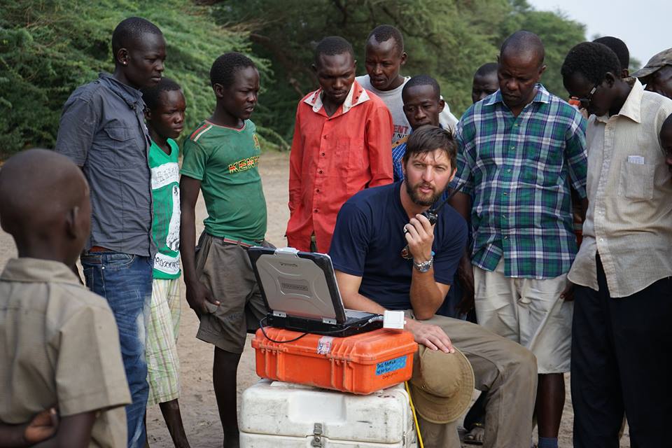
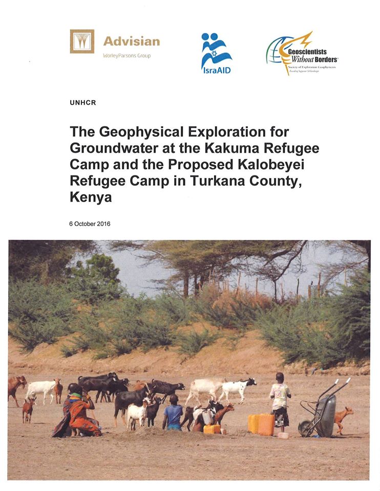
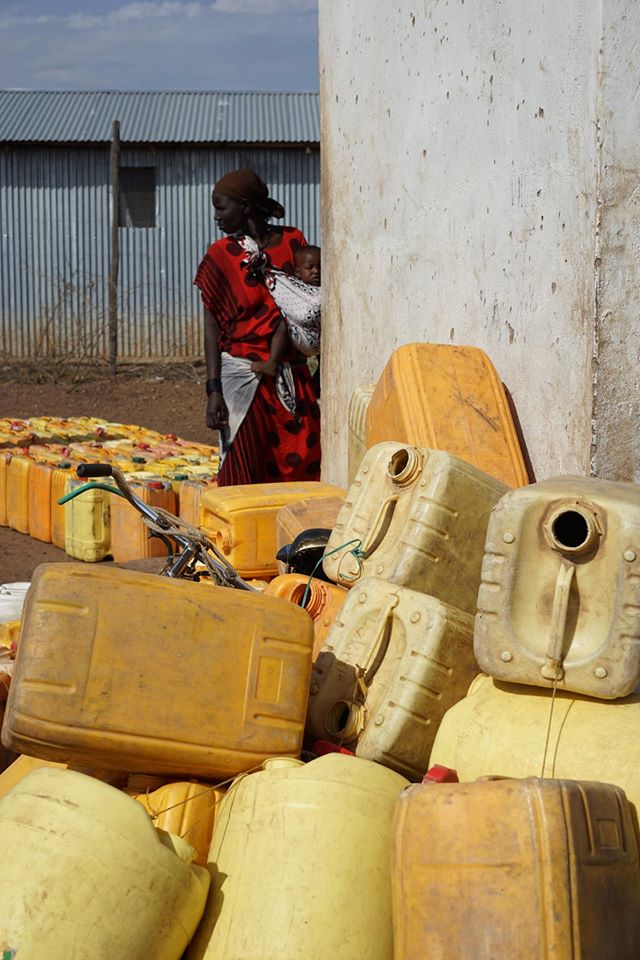
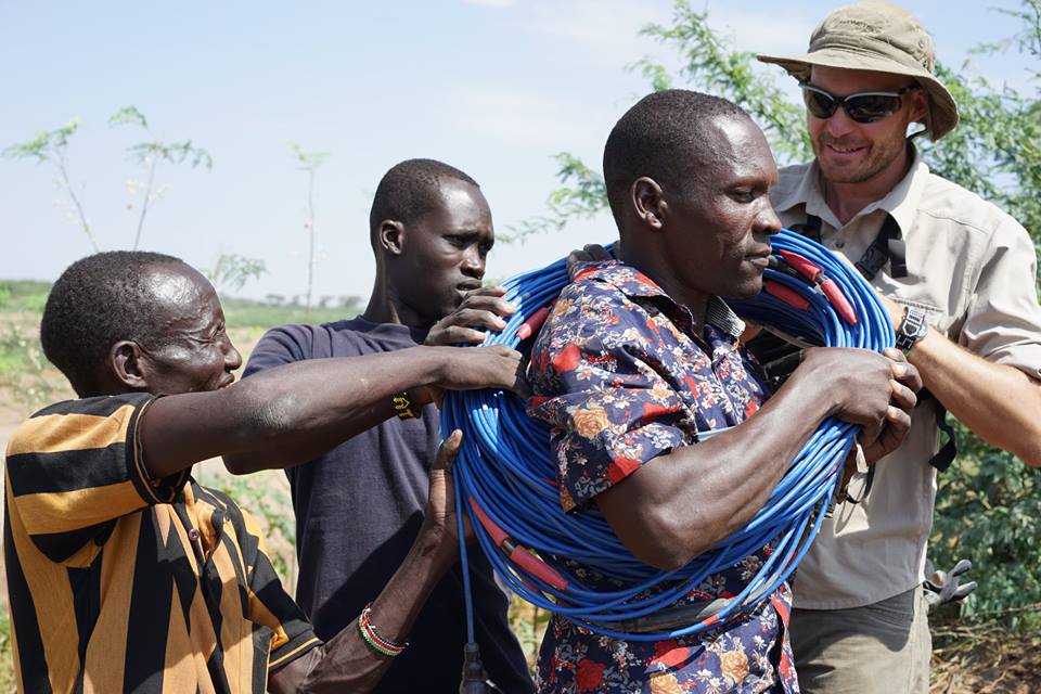
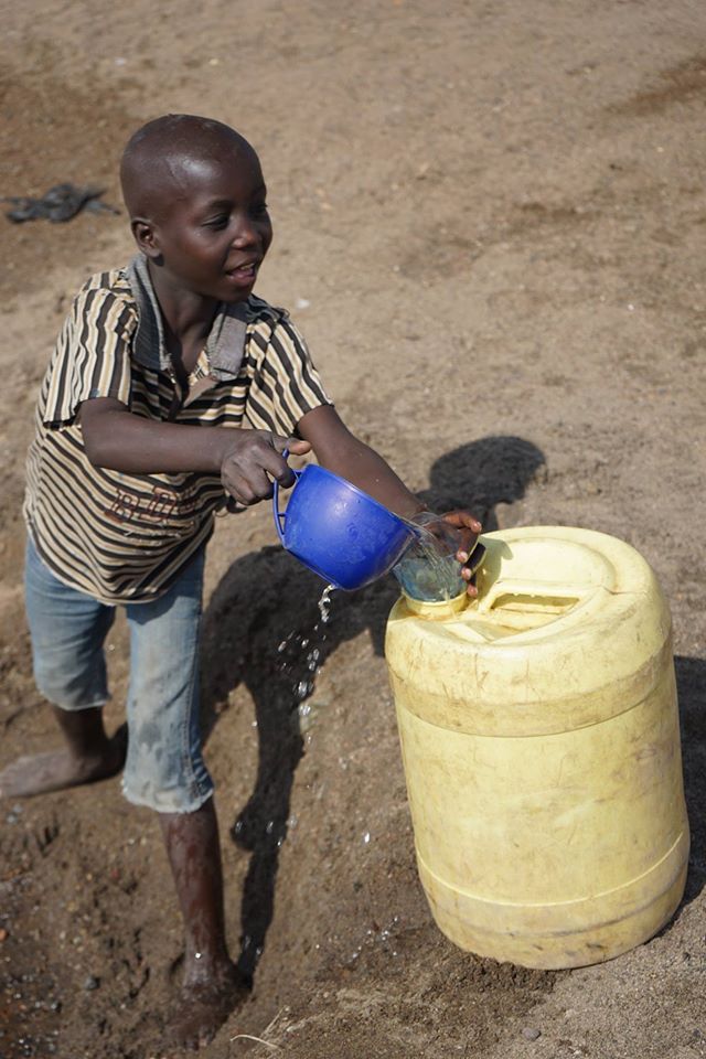
It is a year since we began our 2 week water exploration program in the Kakuma Refugee Camp, sponsored by the SEG (Society of Exploration Geophysicists) GWB (Geoscientists Without Borders) Foundation, and which we called the Calgary to Kakuma Water Project. Using our results, in May 2016, UNHCR drilled 3 successful wells (that is, 3 for 3, with no dry or saline holes) to depths of 56, 74, and 62 meters below ground surface (mbgs), in what we termed in our report the “Northern Well Field”. The wells tested for sustainable yields of 40, 45, and 29 m3/hour, respectively. Given UNHCR’s practice of pumping supply wells for only 10 hours over each 24 hour period, this is enough water for 57,000 refugees, given UNHCR’s target of 20 liters per person per day. We issued our full report in May 2016, and finalized it, after UNHCR review, in October 2016. The report is currently available in its entirety at www.paulbaumangeophysics.com (still in construction) We are planning to take on a similar project in the coming year, but hopefully in an even more challenging and water scarce location! Computer models are rarely perfect, and are often very wrong. The computer predictions that estimated the height of the tsunami waves reaching the Acehnese coast underestimated their size, and hence the tsunami's destructiveness. As such, a team of Japanese, Indonesian, European, and American (USGS) earth scientists came to Aceh during the early weeks of absolute mayhem following the December 26, 2004 Boxing Day tsunami. From January 20 to 29, 2005, the scientists collected wave height, erosion, sediment deposition, flow direction, and other information to calibrate their models....and to better predict the impact of the inevitable next tsunami. So, while the kite photo of the the tugboat and the coal barge evokes the power of the tsunami wave, the purpose of the photograph was to show the height of the wave. The coast of Lho Nga was one of the first locations that the scientists visited. Here, from the height of the stripped vegetation, they measured the tsunami wave at 31 m above sea level. Of course in 2004 and 2005, small drones were not available for photography. And according to kite historians, Sumatra is where the kite was invented as natives mimicked the shape and ribs of falling leaves to build the first kites.....and it is still a popular hobby everywhere in Indonesia. The coal barge was carried from about 2 km offshore, only to be deposited on the only coastal road of Aceh. The coal had been destined for the Lafarge cement factory in Lho Nga. When I returned on a later trip, the then unemployed cement factory workers had built a little cafe under the shade of the bow of the barge. Another measure of the height of the tsunami wave was the decapitated monument in the harbour of Banda Aceh, which had originally been erected to celebrate the Aceh War against the Dutch. One of the very positive outcomes of the Indian Ocean tsunami in Aceh was that the destruction caused by the tsunami convinced GAM (Gerakan Aceh Merdeka), the Free Aceh Movement, to agree to a ceasefire so as aid workers could move into the area. The December 28, 2004 ceasefire eventually metamorphosed into a lasting peace agreement. And certainly during my time in Aceh traveling by boat, helicopter, hitchhiking, and on foot, I never encountered any sort of threat from any of the GAM fighters. Too bad the 6+ year catastrophic drought in Syria did not have the same effect there. The tsunami warning in southern Chile today reminded me of the the 26 December, 2004 Boxing Day tsunami, 12 years ago. In retrospect, it was the first in a long string of natural and man made disasters that has struck our planet in the recent past. I, like everyone else, was transfixed to the astonishing but horrific images that appeared in the media. And like most of us, my holiday good will was with the people of the rim of the Indian Ocean, and my only thought, like many, was if only there was something I could do..... I was fortunate to be seconded to UNICEF in Aceh Province, the earthquake epicenter in Indonesia, to assess the impact of the tsunami to water wells and water supply infrastructure, and to begin the redevelopment of groundwater supplies. It was in Aceh that I learned, first hand, what one person can do....and I do not mean me. While assessing the impacted wells in the capital, Banda Aceh, I came upon some Indonesian graffiti scrawled on a broken cement wall, beneath a fishing boat suspended one floor above (I shot the air photos with a small film camera suspended from a frameless kite - no kidding!!). 3 years as the only white person on an island off the coast of Indonesian Borneo left me with a good grasp of the language. "With the permission of Allah, this boat above saved 54 persons." Hmmmmm. A young man, pictured below, stepped out and explained that there was not one, but three tsunami waves. The first wave deposited the fishing boat on the second floor of the standing building. He climbed into the boat, and then helped 53 others into the craft. The following two waves destroyed the remainder of the neighborhood....and certainly left me with no better explanation than only by the grace of Allah.....As the young man spoke, the survivors, most living in tents set up on bare foundations within 50 m of the rescue craft, stepped forward to add their personal stories of salvation. Very few people were injured by the tsunami. Most either died, or survived. And each story of survival was similarly moving. I was always pleased and moved to be a listener. Who am I to contradict that giant of Jewish legal experts and philosophers, Rabbi Moses Ben Maimon, or Maimonides of the 12th Century? Well, I think his eight levels of righteousness through giving has to be turned on its head for the 21st Century. Maimonides said that the penultimate act of giving is anonymously to a recipient who does not know the donor – and donor can mean money, food, services, an act of kindness, teaching a skill, etc. Well, this is what most of us do, at least some of the time. You pick a charity that fits your values, type in your credit card number, and hope that the Red Cross builds a shelter for someone deserving in Haiti, UNICEF provides 17.6 children suffering from famine in Chad with 22.8 meals, or Oxfam drills a water well in the Turkana. Yesterday, returning to the airport in Entebbe, Resty of IsraAID (as well as the volunteer Chairman of the Board and one of the founders of Little Light), asked the driver to drop me off at the Little Light Children’s Center in the Numowongo slum in Kampala for a few hours. Numowongo is one of the two sister slums of Katwe (yes, as in the already critically acclaimed, just released Disney film “The Queen of Katwe”). Resty had arranged for Godfrey, the director, to escort me to the home of Elizabeth, a 7 year old slum dweller girl, whom our family supported last year in school. The cost of support is pathetically small, and I was certainly plenty pleased with myself to chalk one up for charity without having to walk across the slum or Elizabeth having to meet me. In fact, I was much more looking forward to having a cappuccino on one of the beaches near Entebbe, or doing a little gift shopping in the Oweino Market in Kampala, but I was too embarrassed to tell Resty that. Suffice it to say that walking along the abandoned railroad track, across the mountain of refuse to Elizabeth’s home was infinitely more powerful than pressing return on the keyboard. People often ask me to recommend NGOs for donations. Generally, I say small is better than big, but beyond that I am always hesitant as I see it as completely a personal choice reflecting personal values and resources. Nevertheless, riding the wave of Phiona Mutesi and “the Queen of Katwe” (who unfortunately truly is one in a million), having met most of the staff (most or all of whom live in the Numowongo slum) and students and board members of Little Light, having been there twice, and having met a few of the beneficiaries at their homes….you certainly can be confident that any donation to Little Light Uganda http://www.littlelight.ngo/ is massively needed and will be well used. Over the last few days I have learned to always carry a sharp knife with me in Acholi land. The students, one or two of the IsraAID staff, and myself have been traveling well outside Gulu town, from village to schools to small family compounds, siting wells. And wherever we go, especially the small family settlements, we are offered guava, oranges, jack fruit, papaya, or cassava. Thumbs up for the first four, but the uncooked cassava to me tastes like what it is, a woody root. And with typhoid especially common lately, I am always insistent on peeling and cutting my own fruit. If it was a couple months later, it would be mangoes galore on offer. I have only encountered generosity wherever we have traveled in the Gulu District. Wednesday, we traveled through an area where several of the students indicated there had been a large number of camps. I pressed them a bit to get a better sense of what the Camps were like, as I still had scant idea of whether they were tents or barracks or Kakuma-like shoulder high mud brick walls with tin roofs. And where someone would point to an area of tall grass or maize and say that there, in 2005, were 10,000 people, I would see only vegetation. The common narrative seems to be that when the NRM (National Resistance Movement, the ruling political party of Museveni since 1986…..and no, there being no real opposition here the name is not fitting) could not effectively defeat Joseph Kony and the LRA (generally understood to be a few hundred field commanders and a few thousand child soldiers), Museveni coerced 90+% of the Acholi population into the “Camps”. The UPDF (Ugandan People’s Defense Force) claimed the only way to effectively defend the people was to move them into centralized IDP camps where they could be protected, and in this way the countryside would be more conveniently transformed into a battlefield where Kony and his army could be starved out and quickly defeated. Most Acholi would say that Museveni used the LRA as an excuse to destroy their villages, culture, and economy. Kony was never caught or defeated. Beginning in 1996, 1.7 million people were moved into the camps. The camps were poorly protected. The actual houses were hastily built versions of the typical circular, mud plastered, thatched Acholi houses….except, over an area where typically a village might have 50 houses widely spaced, in a Camp might stand 1000 houses spaced one next to the other. Food and water were scarce, and work even more so. Alcoholism, sexual violence, child abuse, and all the other problems that occur in IDP camps exploded. Not only was the UPDF of little use in protecting the IDPs, but UPDF soldiers returning from interventions in the Congo brought with them HIV and Ebola. Malaria, cholera, and other diseases were epidemic. The IDP Camps in the Gulu area had one of the highest mortality rates in the world. Beginning in 2005, people started to gradually return to their villages. As camps were vacated, the mud brick walls were toppled, and melted back into the African red clay landscape. Being here in Uganda with IsraAID, I of course have to send my friends and family New Year's greetings full of health, happiness, and peace. I collided with the Holocaust/Uganda connection again a few nights ago. I had a Tusker (I prefer the Ugandan Nile Specials over the Kenyan beer, but the Tusker was colder) with a Ph.D. candidate from Warsaw, Camilla, who has been here in Acholi Land over the last 6 years. She is exploring the process of reconciliation here in Acholi Land following the 24 years of low grade war during the Joseph Kony and Lord's Resistance Army period. Interestingly, she is comparing the process of reconciliation here in Acholi Land to Poland under the Communists, if I understood correctly. It could have just as easily been a comparison of the Holocaust period had her research occurred 40 or 50 or 60 years earlier when there were more survivors, and I certainly do not yet know her conclusions. But the contrast is striking... in the West, we generally pursue reconciliation through justice and education. Here in Uganda, where there are no memorials to the Idi Amin or Joseph Kony victims, and where very few people will openly or even in confidence speak to me about their personal experiences, the path to reconciliation seems to be forgiveness, or at least forgetting. Geophysics provides no answers to these complex questions. But what I do know, is that when I am out for a long run in the desert in Turkana or through the bush in Acholi Land, and I suddenly burst into a Turkana family compound or surprise Acholi farmers at work with machetes in their fields, and their immediate expression is that of suspicion, invariably a few words of greeting, Ejoka in Turkana or Itye maber in Acholi, will set off the widest grin imaginable. Of course my poor pronunciation may be part of the source of amusement. But I prefer to think that using a few words of the local language immediately demonstrates an effort to identify with the local community, and to show some respect for people that certainly deserve it. And what more could anyone want from a stranger. 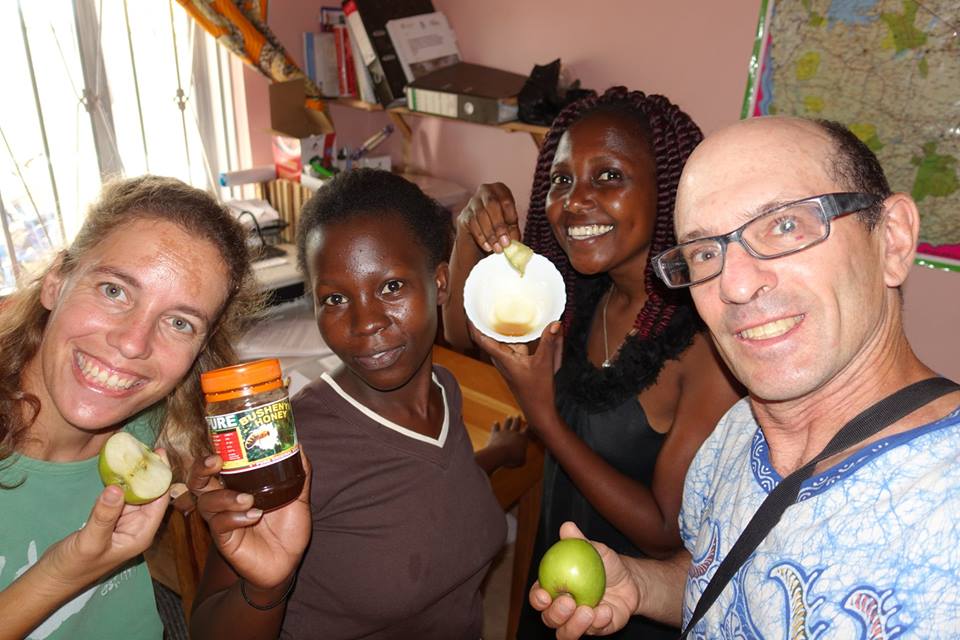 The primary purpose of our efforts here in Gulu is to provide the training for marginalized youths who spent much or even most of their lives in the IDP camps created during the Joseph Kony and LRA violence of 1986 to 2009. Our objective is not to find water or repair hand pumps, but to train the students to do so. Being practical in nature, though, the training involves field surveys and field repairs. Myself and my 3 IsraAID colleagues do not choose the sites, as it is up to the students to identify the village (usually their own), identify the problem (broken pump, additional well needed, etc.), organize or identify the community contribution (labor, cash, food, etc.), and direct us to the location (always an adventure!). Things do not always go as planned. On Tuesday, one of the students, Kagwar, took us on a long drive to a small village in the Omoro District, south of Gulu. Other than the handle having been removed (i.e., likely stolen), the hand pump worked fine, and was located a mere 15 m from a crystal clear alternative water source flowing from a carefully constructed and protected boxed in spring. Before we could become too irritated, though, he said there was another broken pump nearby. Abili village, in fact, was not so near, but the pump was definitely broken, and the area was certainly high need- 50 households depended on the well, and the only alternative water source was a cloudy puddle that seeped out of a clay wall. The well had been drilled in 2005 or so while almost the entire village had been interned in a nearby IDP camp with thousands of Acholi. The well had not functioned since 2008. The history of the site was given to us by a very articulate and gracious woman, Joyce, who lived only 50 m or so from the well. Besides the history of the well, she voluntarily told us her own story including 12 children, a widow from HIV, kids lost to HIV, and the challenges of raising a family while living with HIV. The reality, though, is that even in small, impoverished villages, those who acknowledge and directly address HIV can receive drugs, health care, and carry on. The site was well suited for a geophysical survey. The need for a functioning well was there. And the pump assembly was a mess, with pipe lost in the hole, the downhole pump cylinder needing to be fished, the chain that connects the handle to the pump rods missing, etc. It was a disaster, exactly what the students need to see. Unfortunately, the missing piece was that the village pump maintenance committee had no money, and was completely unprepared to make any contribution of any kind. 3 riser pipes, a pump handle, 3 rods (that connect the handle to the piston in the downhole cylinder), a cylinder (the downhole assembly of pistons and valves that pushes the water to surface)...it all adds up to about 650,000 Uganda Shillings or $200 or so. Fortunately for me, I just find the water. It is these community mobilization efforts that are completely unfathomable, as well as stressful. Resty, the IsraAID Ugandan field coordinator, did all the negotiations with the LC1 (the community leader), and she is no pushover at all. But given we were there, and the story of the village and what we could see with our own eyes, she decided to carry on. Not an easy decision, but probably the only one. The class had carried out two geophysical surveys on their own, repaired the pump, and shock chlorinated the well before we returned to town. Though Resty and I felt a bit duped, the class was buzzed from a job well done, and we certainly could not have simply walked away from such a wretched situation. On Wednesday, September 28, we spent the morning in the classroom, or rather a large tent. The Acholi pump mechanic and driller spoke to the class about the business aspects of pump repair and drilling, specifically, preparing Bills of Quantities. If you ever wanted to know how to say “6-inch slotted, thick walled PVC well casing” in Acholi, or to know the cost of galvanized pipe in Kampala versus Gulu, this was not a talk to be missed! I went over the results and interpretations of our geophysical surveys to date. The technique of 1D resistivity soundings was developed in 1916 by Frank Wenner at the United States Geological Survey, and I may have a Nile Special beer tonight to celebrate the centennial anniversary. Though the method has become somewhat obsolete over the last 20 years in much of the world, it is actually remarkably effective in Northern Uganda for identifying aquifers. And unfortunately, I am old enough to have used and taught the technique extensively. In the afternoon, we carried out surveys and hand pump repair at the nearby main campus of the University of Gulu, which in fact is short of water. I was grateful to have a day without a long, bone jarring drive to another remote location. But on Thursday, one of our students guided us to his distant village of Oboo, in what I was told is the “famous” Lamogi County. We headed north on the road to Juba in South Sudan, and in the direction of where, according to this week's numbers from UNHCR, 400,000 refugees have crossed into Uganda. I was surprised to see only a few UNHCR supply trucks heading in the same direction. IsraAID staff just returned form a "needs assessment" of the camps in the Adjumani area. Medical care, food, educational resources, housing, and trauma counseling are all, of course, in desperate need. What struck me in their photos were the long lines of empty 5 gallon jerry cans neatly lined up near large, black, and obviously chronically empty 5,000 liter water tanks - obviously empty as there were no people filling the containers. We are expecting in our water exploration class next week a few WASH staff from NGOs working in the water supply sector at the camps. There are no road signs to Oboo, and I doubt if you will find Lamogi on a map. According to the LC1 (Local Council) who introduced the village to us while the students and the one mzungu, me, stood around the faulty hand pump, it was here in 1911 that the Lamogi, armed with only bows and spears, successfully fought the British. And it was only when the British used gas to asphyxiate the Lamogi fighters who were hiding in the nearby Guru Guru caves, that the British gained the upper hand. And so I learned that perhaps the Germans do not have the dubious claim of having been the first to use chemical weapons in World War I, though all Ugandan students learn of the Lamogi Rebellion. Well, the students quickly pounded out two geophysical surveys entirely on their own. And the water well was in need of far more parts than we had been lead to believe, or had brought. So, instead of returning early to Gulu, I walked the long path to the alternate water source the village was using, and got a bit of a Heritage Park-like tour of Acholi village life! Check out the photos I am now in Gulu, northern Uganda. What is it like? I can only compare it to Kakuma and the Turkana desert. The previous issue of the Bradt Uganda Guide says "travel in the vicinity of Gulu, Lira, and other areas north of the NIle is highly risky, if not downright suicidal..." Gulu is from where Zika and the evil hemorrhagic sibling of Ebola, the Marburg virus, sprang from. There are diseases here like "Nodding Sickness" that are already epidemic and of unknown origin, yet are unheard of outside of Uganda and even outside of Northern Uganda. The Acholi people here suffered under Idi Amin, and then they were brutalized by Joseph Kony and the Lord's Resistance Army (LRA) from 1986 until 2009. To "protect" the population from Kony, the current President, Yoweri Museveni, moved 90+ % of the population to internally dispaced persons (IDP) camps where they were decimated by malaria and HIV, culturally undermined, and were an even more easily targeted population for Kony as well as the Ugandan army. What's it like here compared to Kakuma? The town and area are much closer to Ubud in Bali than anything in the Turkana. Fresh fruit and vegetables in the largest produce market I have seen anywhere in Africa, kind people, a strong culture, lush vegetation, cafes, restaurants, badminton matches at the Luo Guest House on Sunday nights, an indigenous architecture, anywhere worth getting to (including the University of Gulu where I teach) is a pleasant bicycle commute, every meal begins with a passion fruit/papaya/banana/avocado smoothie, fesh fish from the Nile or any of the many nearby lakes,,....it is not so bad here. But the Gulu district is very poor, with youth in particular lacking employment opportunities, and much of the energy of village life is engaged in hauling water. Last November I helped teach a course to about 50 Acholi young men and women on hand pump repair, manual water well drilling, gorundwater, and water exploration. The hand pump repair business has continued, partly due to the chronic failure of NGO installed hand pumps in Uganda, partly due to the excellent training course IsraAID put on, and partly due to the hand pump repair kit donated by WorleyParsons to the IsraAID students. And the students know how to drill, and have been making a business of drilling new wells. However, some dry holes have been drilled, and that makes for unhappy villagers. So I have come back to Gulu with geophysical equipment, donated by ABEM of Sweden, that will be left here, and I will be putting all my efforts into training the Acholi students on planning, executing, and interpreting water exploration programs here in the Gulu area. This week I will be training the 50 students of IsraAID's classes 5 and 6; next week I will work with the 100 or so students of classes 1 through 4. At the same time, Polycarp, a local Acholi master hand pump mechanic, will be carrying on with the hand pump repair training, and learning a bit of geophysical water exploration himself. Unfortunately for everyone, including my class, my drone was confiscated at the airport, though I hardly consider myself a security risk...but sorry, there will be no air photos of the wonderful vernacular village architecture of Acholi Land. |
Categories
All
Archives
August 2022
|

 RSS Feed