Kakuma and NairobiSaturday morning was hectic. The transport truck to carry our 1600 kg of equipment to Nairobi showed up early. It was fortunate though, as Josie and Paul, even with the students, would have been challenged to complete the final packing and loading. Doug, Landon, and Colin, who were already experts on packing and repacking the gear from their December program in central Turkana took command, and we had the truck on its way for the two day drive to Nairobi. Erin, Franklin, and Randy took the morning to search for wrist knives and other Turkana “accessories” in the Turkana market, but the market is usually not busy until the afternoon, as the Turkana walk from great distances to get into town. By 11 AM, everyone but Josie and Paul were on the road south to Lodwar and then Nairobi. Personally, I would trade three more days in Kakuma and a direct flight out of Kakuma on UNHAS – UN Humanitarian Air Service – any day over a repeat of the Lodwar/Kakuma drive.
In any event, a weekend in Kakuma is not to be missed! Following my last lunch together with the IsraAID refugee and Turkana students, and lots of good byes, Josie and I started walking on one of the main “roads” into Kakuma 1, heading toward Franco’s for a hot coffee, though Josie could not quite get it why anyone would opt to take a stroll on one of the dustiest roads, in one of the hottest places in Africa, to drink hot coffee of dubious provenance under a baking hot zinc plated roof. And the roads are very dusty. After walking through the mud brick housing and thorn fenced compounds of the Lost Boys from Sudan, one takes a sharp left through the massive corrugated tin gates that close at 5:30 PM, and open again at 6 AM, and one enters the Ethiopian Market area. Past a large public sign board with crowds looking at the latest course offerings or UNHCR emigration interview schedules, another sharp left, step into a dark room and onto a polished mud plastered floor, and one has arrived. As the enjera and other food finished long before, Franco’s is nearly empty of customers, and service is quick. Of course Franco’s is empty of Franco as well, as the story is he opened a restaurant in New York City years ago. And even the Ethiopian refugee artist who did the interior design ran off years ago caught up in a scandalous relationship with a Ugandan refugee. Customers do come in and out for tea or coffee, and over a half hour one can hear spoken, without leaving one’s seat, Swahili, Arabic, Amharic, French, Turkana, and a buffet of tribal languages that do not register for me at all. But eventually it is time to move on, and do what one does in a market in a refugee camp, go shopping! First it is to the Congolese shops, a mini-market area within the Ethiopian Market, where they carry the craziest batiked fabrics. And then, a bit of food shopping. We are invited to a refugee’s home on Sunday for a farewell lunch as this Sudanese refugee is giving up on Kakuma, and will try his luck on getting home. Few refugees eat lunch, and no refugee has food to spare or for entertaining, so this is something special. What do you bring to such an event? A bottle of wine? Chocolate? Try a kilo of rice, a half kilo of sugar, and 2 liters of cooking oil. We then pick up a few mangoes for personal consumption, wind our way over to the Somali Market, and head home. Though it is the dry season, and the streets are dry, there are many puddles on the sides of the packed dirt roads, probably about 650 of them, because that is how many water tap stands there are in the Camp. We run into an NGO worker driving through the Somali Market distributing antibiotics to combat trachoma, an easily preventable disease caused by the bacteria Chlamydia trachomatis. All you need to do is wash your face! Left untreated, it causes blindness. In the Camp the percentage of people with trachoma is 44% - yes, that is 44%! Back to the puddles, I overhear a conversation with the health care worker that the clinics and hospitals are packed….over 7,000 cases of malaria this week….over 6,000 cases last week. I can’t restrain myself and interrupt, as we are standing next to a Camp Green Lake sized puddle. “What about digging a soak pit at each tap stand?” The puddles at the tap stands are mosquito incubators, and the large number of people gathering at the tap stands provides obvious vectors for malaria to jump from person to person. A “soak pit” is simply a small bucket sized hole in the ground with rocks or gravel. The response to my suggestion is that digging 650 pits is an incomprehensible expense. Who will dig? Who will pay? The problem with a day off in Kakuma is that one has time to look up from whatever is keeping you busy during the week, and think about all the craziness that surrounds you. We have challenges here that even Stanley Yelnats did not face.
0 Comments
Sunday and Monday January 24 and 25, 2016 By Sunday morning I have worked through almost all the 11.4 km of resistivity results and 5.4 km of seismic refraction data, and prepared 3 presentations. I am fortunate that the other 6 geophysicists made a tremendous effort of completing the data processing before they drove off to Lodwar on their way to Nairobi, on Saturday morning. The presentations are designed for 3 very different audiences, the Turkana village head of Kalobeyei, the 25 or so WASH students in Kakuma who helped run the survey, and the final meeting with UNHCR and NGOs involved in the WASH sector. But before going to Kalobeyei for the first meeting, Josie and I, and IsraAID staff visit the home of one of the South Sudanese students/IsraAID staff/WASH instructor/friend who is readying to leave Kakuma, and return home. There are no fences to stop a South Sudanese from walking out of Kakuma and taking a bus north to Lokichogio and the border. There is lots to make returning dangerous, though. The civil war in South Sudan still varies from a simmer to a high boil. For Nuer refugees who came to Kakuma at a young age, they don’t have the distinctive coming of age scarring on their foreheads that marks them as Nuer. As such, they may become mistaken targets of Nuer violence, and remain targets of violence from other ethnic groups. Add to that land mines, a failed government, pressures on young men to join the military effort, expensive and dangerous transport, etc. Beyond simply offering security, there is community in Kakuma, but for the vast majority there is also a hopeless future, and returning home, perhaps even to family, may provide an attractive option. For someone like this particular South Sudanese staff person, extensive experience as a WASH instructor, an excellent command of English, and outstanding references from the NGO community may also assist him in securing a position with an NGO in South Sudan, where he will not be subject to the stringent “incentive pay” caps that UNHCR and the Kenyan government place on all refugees in the camps in Kenya. Lunch is delicious! A traditional spiced dish of couscous, kale, and goat. We eat in a mud plastered, gabled room/house of about 2 m X 3 m, with walls about 1.3 m high. We all sit on the floor or a low bed, as standing puts one’s head too close to the intense heat radiating from the corrugated tin roof. We drink soft drinks that we have brought, something that most of us would never touch back home, but is often a daily treat in the heat of the Turkana desert. We talk about South Sudanese cooking, the journey home, the civil war, English football, and a bit of camp gossip. Then it’s time to go to Kalobeyei. The Camp is divided into Zones and Blocks, but the older areas of Kakuma 1 are a maze of compounds of semi-traditional structures behind fences of thorn branches and corrugated tin, so we need to be guided back to the main road just as we were guided in. In drive to the home of the head of the village of Kalobeyi, Alfred Kapoko. He lives in a compound with his large family and an architectural mix of a small concrete house along with several traditional manyattas. My computer is charged, and we sit on chairs in the shade behind his home. There is Alfred, Jack Jones from IsraAID, the assistant camera man Josie, and myself. We slowly and methodically go through what we did in the field, where, what we found, and the conclusions of where to drill and where not to drill. Alfred graciously allows Josie to film the entire meeting. Alfred has spent hours with us in the field, and is intimately familiar with the area of course. He is a quick learner. Moving from maps to cross-sections does not seem to phase him. He stops me when he needs to cut through the jargon. He passes on the traditional knowledge of the area, but accepts the science while recognizing the geophysics has its own family of uncertainties The main points are clear to him….Elelia and Esikiriat lagas are saline. Kangura laga, to the west, has some possible water well targets. But the best area is a few kilometers west of Kangura, especially south of the Lokichogio highway where herders from his area will not have to cross the road. I am surprised to hear Alfred describing a long term vision where there is perhaps enough water and feed that some Turkana can abandon their nomadic ways, along with the deadly cattle raids and other inherent hardships, and settle down on grazing land like we do in Alberta. Driving back to Kakuma at 6:30, it’s another evening of Nuer dancing in the soccer pitches! Monday morning, January 25, I present the results of the work from both Kakuma and Kalobeyei to a combined class of the 25 students from IsraAID’s advanced WAMTECH (Water Management TECHnology) class, and the 25 students of the new introductory WASH class. Josie is once again filming. The new students are both inspired and confused. Maps, cross-sections, geophysics, are all new to them, and I do not have the time to go through everything in the required detail. But for the students who completed the 8 months of WAMTECH training and carried out the field program, seeing the results and the interpretations seems to tie their efforts and learnings together, and there is certainly a sense of satisfaction in the air of a job well done. There are some good byes, and then a “mosquito hand clap” – it’s an East Africa thing-then off to UNHCR. The UNHCR/NGO presentation is at noon. It is not an easy crowd to deliver a condensed version of 12 days of exploration, as there are no geophysicists or hydrogeologists – they are mostly from the Sanitation and Hygiene part of WASH, or public health, or livelihoods. The questions are reasonable, but not necessarily easy to answer. What will be the fluoride concentration in this area? Will there be enough water for agriculture? Why did you not collect data in the saline areas east of Tarach laga? Etc. Nevertheless, I am pleased that they are engaged, and recognize the potential of not only what was done, but what could be done. We did present results that directly addressed our initial objectives, though: 1. Identify improved water well sites east of Kakuma 1, 2. Identify water well sites east of Kakuma 3 and 4, 3. Identify drilling sites with potentially low fluoride, and 4. Identify drill sites in Kalobeyei. We very much look forward to receiving some drilling results, and modifying our interpretaitons if necessary. We finished the UNHCR meeting at 1:30. Off to the airport and on to the UNHAS flight to Nairobi. I grab a window seat on the left side of the airplane to catch views of Lake Turkana. Josie films the takeoff – from her seat in the plane. No regrets about missing out on the return drive to Lodwar. Today Peter, one of the local Kakuma men that took part in the water class showed us around his home, and where he and his community gets water from. Thursday January 21 we were back “home” carrying out more electrical water exploration west of Kakuma 1, trying to bring a source of water closer to Kakuma 3 and 4. Meanwhile, the seismic crew was back in Kalobeyei carrying out surveys where we had already done the electrical work. The seismic defines the top of rock, and whether the rock is fractured or massive, and the electrical work identifies whether the pore spaces are filled with fresh water or saline water.
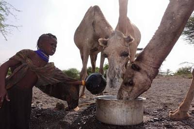
On Thursday we began to wind down, in a manner, with Erin Ernst staying back at Camp to push ahead with data processing and map making. We want to present at least our preliminary results to UNHCR, to the various NGOs involved in the water sector, to the village leader of Kalobeyei, and to the students before Paul leaves Kakuma on Monday January 25….especially as we have some great drilling targets!! We have also mapped some extensive areas that are saline everywhere along our lines, and at all depths, so we certainly do want to present these areas as ones to avoid. All of our information will be compiled in hard copy and digital reports, as well as be summarized in easy to understand maps overlain onto satellite photos. Thursday, we bought a goat and had it slaughtered, and we gathered together in the evening at the WFP (World Food Program) compound with our IsraAID colleagues and other NGOs in the WASH sector to eat nyama choma (roasted goat) along with much missed fruit and avocado salads, and to celebrate what we hope is a job well done. While most of us are enjoying, or at least tolerating the food, a few of us, including of course our 1 vegetarian, would like a bit more variety from goat and ugali (maize flower and water). In fact, the assistant camera man Josie has become delirious, often seeing a soft, sweet, light, sponge cake in the pan when it is simply once again packed with dense, tasteless ugali. Nevertheless, the evening was interesting, as often information is passed on over a few goat ribs and cold Tuskers that cannot be said in official recorded NGO minutes. For instance, it was both sad but satisfying to hear from several sources what we strongly suspected – that many, many more dry holes are drilled in Turkana than are ever reported, and the routine methods of water well siting do desperately need improving – along with reporting, archiving, monitoring, drilling, pump installation, and just about everything else water related. But it was absolutely tragic to hear from a Turkana working in the NGO sector what we had heard rumoured, but were not sure was true, that when water and grass become so scarce that the future of a livestock herd is hopeless, the Turkana men may shoot their animals, their family, and themselves. Friday was hectic. Erin carried on with our processing. Randy and Franklin, along with the students, completed our last geophysical survey (an important saline control well of known depth). Of course by now, the IsraAID students are doing most of the work, and it would not be a surprise if this class exceeds the 60% employment rate of the last class. Doug and Colin packed and crated most of the equipment. Brendan and Josie filmed subject matter of people and water in Kakuma town, and Landon and Paul traveled though the Camp and back to Kalobeyei doing some water and soil testing on physical samples. While testing a sand and water slurry in a scoop hole in the the main laga, Laga Tarach, we saw goats, women, and children drink out of the same scoop hole no bigger than a large spaghetti pot. And then a very articulate, English speaking Turkana man came over bemoaning how the water is unhealthy, full of bacteria, spreading disease from animal to person, and person to person. And then he took a bowl….and drank from the same scoop hole! Meanwhile, there is a hand pump perhaps 150 m distant, and a UNHCR supplied water tap in the town 300 m distant. It costs 10 Kenyan Shillings – about 10 cent US –to fill a 20 liter jerry can from the hand pump, and 5 cents from the Kakuma town water tap. For many Turkana, this is either more money than they have, or more money than they are willing to spend. January 20, 2016 Today we collected a line of resistivity north of the only existing water well for at least 12 km in any direction at Kalobeyei, and in the very busy dry river bed/sand highway of Laga Esikiriait. We have a good prospect on the former, but the Laga was entirely saline everywhere along our survey. We expected the area surrounding the proposed 60,000 person Kalobeyei Refugee Camp expansion to be empty of people, but every day we have encountered many nomadic Turkana Camps and hundreds of camels, donkeys, and goats on the move. The Turkana dig down through the sand to find water for themselves and their livestock, using nothing but sticks, tin cups, and perhaps a large pot. But already, only a few weeks into the dry season, most of the lagas are dry, and the Turkana, their herds, and all they own are on the move to other areas where they hope to find grass and water. It is difficult to imagine what the situation will be like in another 2 months into the dry season, or if the spring rains do not come. Though most Turkana are illiterate and do not have radios, and I have never seen a nomad with a newspaper or a book, they are all aware of global warming, increasing temperatures, and less predictable rainy seasons. The seismic crew worked in the Camp, shooting through a well that tested for a massive amount of water at 100 m3 per hour (about 500 gallons per minute, enough for a small town), but was abandoned because of very high fluoride. It was challenging getting good data as “quiet on the line” does not mean much when thousands of school kids are walking home and they suddenly spy a muzungu (white person) giant swinging a sledge hammer on top of a hill. The refugees tried to chase the kids away with sticks, but of course that all turned into a game and more ground noise on our geophone array. We are hoping to image thicker sands and deeper bedrock in that location, so as to site an equally productive well without the fluoride.
January 19, 2016 The planned 60,000 person refugee camp expansion of Kalobeyei is about 10 km west of the present 185,000 person Kakuma Refugee Camp. The last 3 days we have been exploring for groundwater resources near the planned Kalobeyei Camp specifically for the host Turkana community. Regardless of the presence of the new camp and any tensions it may create, the last 3 days working, seeing young children and old women digging in the dry laga bottoms for any significant amount of moisture, has convinced us Calgarians that the water situation there is desperate, likely more so than in the Camp. Unfortunately, until today, the prospects have not looked good, as the seismic work has shown bedrock to be only a few meters below ground surface, with no trace of deeply incised sands and gravels. And the electrical imaging work has shown that even where the bedrock is fractured and likely having good porosity, the pore water salinity is very high. But today, we surveyed across an area that also had highly fractured rock, but with resistivity sections suggesting fresh water. Tomorrow, the electrical imaging group plans to continue to map out this prospect. Meanwhile, the seismic crew will move back to the Refugee Camp. Between Kakuma 1 and Kakumas 3 and 4 there is a large laga (dry river bed) that periodically floods and rips out the water lines to Kakumas 3 and 4. UNHCR has tried to drill wells on the Kakuma 3 and 4 side of the Laga, and indeed they have tested for very large yields of water, but the fluoride concentratons coming from the volcanic bedrock have been extremely high, well above concentrations that cause skeletal fluorosis. So the seismic crew will shoot through this area, looking for deep volcanic bedrock. If they are successful, the electrical crew will come through on our last day to determine if the overlying sediment is fresh water saturated sand. Despite the better exploration news today, the highlight was seeing a sight that even our Turkana students and the local Kalobeyei Turkana helpers had never seen. The Turkana raise donkeys, both as beasts of burden, and for meat. However, I had never actually seen a donkey carrying anything here, while the women in particular seem to carry everything, and mostly on their heads. I drove a few kilometers away from the crew to scout our next line. Climbing up on a small rise, I saw 2 older women carrying earthenware water jars on their backs, 2 very young children in rags, and 5 heavily loaded donkeys rapidly approaching. They looked like a 2000 year old version of dust bowl migrants, or perhaps a re-enactment of the Israelites hightailing it out of Egypt. When they saw me, they quickly veered away and moved rapidly into the thorny brush, but a quick glimpse of the lead donkey left me dumbfounded, though I did snap a quick and not so good photo. A camel was riding on top of one of the donkeys!
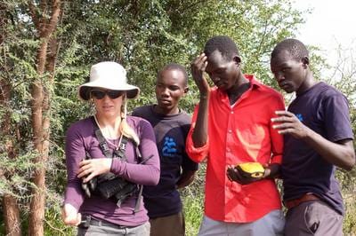
January 18, 2016 It was a relatively uneventful day today in the field. The chai mendazi are losing their novelty. And spooking camels away from our cables has become as routine as swatting mosquitoes in Alberta. Today, we continued to explore for water well drilling targets for the Turkana people living in and passing within close proximity to the UNHCR proposed 60,000 person Kakuma Refugee Camp expansion. The IsraAID WASH students are essentially now running the entire survey with the Calgarians simply supervising. We moved our survey area west, away from what appear to be areas of very high salinity. The results are looking better, and we may have a few targets in an area of saturated, fractured rock. We will continue our exploration in this area for two more days, and then move back to the Refugee Camp for a final day of exploration. Exploring in the Kalobeyei area was one of our main technical goals in the SEG (Society of Exploration Geophysicists) GWB (Geoscientists Without Borders) grant under which we are operating. (click photos for caption) The film crew of Brendan and Josie went in different directions. Josie filmed the opening ceremonies of IsraAID’s latest introductory WAMTECH (Water Management TECHnology) classes, including a women only class. Brendan carried on filming the IsraAID students and Calgary geophysicists in the field, occasionally stopping people in mid-machete swing for a short interview. It is likely his best footage today will be of Landon Woods again carrying 40 kg of cable on his back, but this time working his way through an impenetrable tangle of acacia and other thorny vegetation, and not smiling about it as in some of his cable laying ventures earlier in Laga Tarach.
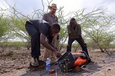
January 17, 2016 One of the subtexts of the IsraAID programs in Kakuma is “peace building,” whether it is between rival tribes from Sudan, political rivals from Burundi, Christians and Muslims, and especially between the host Turkana and refugee communities. Rarely was this so timely as today, the day after an extreme level of tension in Kakuma town after the accidental death of a young Turkana child at a local health clinic. There is nothing like a long day together in the field, in the hot Turkana sun, pounding electrodes and planting geophones, to occasionally make, but usually break a little tension among Dinka and Nuer, Ugandans and Congolese, Darfurians and South Sudanese, or Turkana and refugees – and we certainly have representatives of all of the above and more in our IsraAID WASH student crews. Fortunately, as Calgary geophysicists, we are comfortably ignorant of the usual ethnic divisions, and divide the crews into other such tribal categories as ERT cable laying, seismic source operating, recording, GPSing, etc. In fact, there was a great sense of camaraderie today on both crews, in both the morning and afternoon shifts. Employing Turkana from the local Kalobeyei area, and having exploration goals intentionally benefitting the host community, seemed to bring a friendlier than usual crowd of Turkana herdsmen, along with their camels and goats and donkeys. Having a few extra helpers on the IsraAID student crews gave us quite a bit of time to talk during data acquisition and an extended lunch. Inviting the Kalobeyei village leader along with two area tribal chiefs for lunch, sitting in the shade of a large tree along the laga edge, further elevated the level of cordiality for the day. And an unusual 30 minute dry season downpour that drove us all under the shelter of a large acacia tree further added to the discourse time for the day. To date, we have collected about 6.9 km of ERT (electrical resistivity tomography) data, and about 3 km of seismic refracton data. We are certainly going to have some excellent targets for new water wells in the Kakuma Refugee Camp. Regarding the Kalobeyei area, after a dinner of ugali, rice, cabbage, and goat (for the 9th consecutive night), we did preliminary processing on the ERT data set collected in Elelia Laga, and a quick look at the seismic refraction data from Esikiriait Laga. Rarely are geophysical data absolutely definitive, but today’s data were definitive in their interpretation….and unwelcome. The subsurface of Elelia Laga was clearly saline, and the bedrock of Esikiriait Laga was clearly only a few meters below surface – not the thick water saturated sands and gravels we were hoping to find. We do have a Plan B for tomorrow, though, so stay tuned.
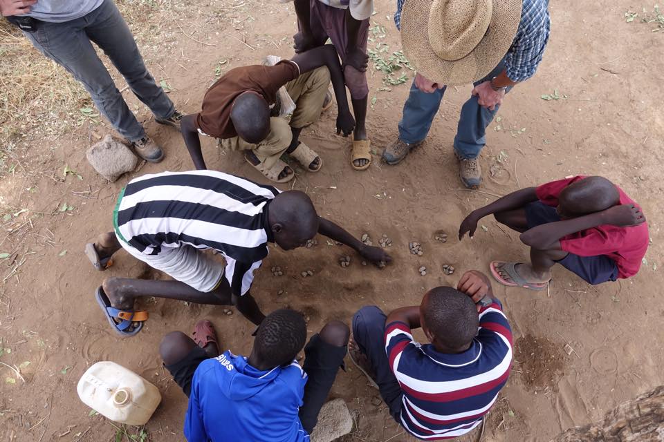
While most of our work days are bookmarked by chai mendazi (milk tea and donuts) in the morning, and a cold drink before dinner. Today, though, the return trip to Camp was announced with gunfire from AK-47s…and a cold drink. The morning was a bit unusual as well. Within the Camp, we have some broad goals from UNHCR, such as to site higher production wells in Kakuma 1, or site a few wells closer to Kakuma 3 and 4, but beyond that, we simply draw ourselves a line on the map of the Camp, and then go do what we believe we have to do to carry out the survey. The next few days, however, we will be exploring for water for the host Turkana community south of the 60,000 person Kalobeyei Camp expansion. As this is Turkana land, we had to of course to meet the village head and the two local chiefs in the existing Turkana village of Kalobeyei. It was somewhat reminiscent of doing work at a northern aboriginal reserve in Canada. There was no burning of sweet grass or shaking of rattles, though, as the village head man Alfred Kapoko got down to business right away. His demands were clear and reasonable, that is, if demanding anything of us can be termed as reasonable given everything we do is on our own time for the benefit of the refugees and Turkana. He wanted each geophysical crew to take on 3 Turkana helpers from the local tribe…check….pay them the going rate for the area….check….feed the workers…check….and promise to provide the report and interpretations directly to the village head….will do. As Alfred Kapoko said so succinctly….”projects come and projects go,” and after everyone leaves we never hear or see anything. Our requests were also quite clear….the refugee and Turkana students also stay on the crews….show us where you would like to drill your wells…and be sure to actually use our maps when it actually comes time to drill. And then we drove off into the Turkana desert to visit, view, and GPS their proposed water well locations as there is no way we would ever relocate ourselves in this flat, incised and dissected, confusing landscape. Why would anyone ever choose to live in this harshest of landscapes?....well, they would not, not even the nomadic Turkana. But the village head Kapoko explained that once the Camp is built and the Turkana see water being piped to the Refugee Camp from Turkana land, the Turkana will build communities on the edge of the Camp. And if they are not provided with water, they will take it, by tapping into pipes or entering the Camp. He explained that Turkana are pastoralists, and while even in this desert landscape there is enough vegetation for the herds, water is the determining factor in their lives. We entered three different lagas (dry river beds), Kangura, Esikiriait, and Elelia, where the Turkana hoped the drilling prospects would be good. As it is only a month since the rains ended, there were still a few nomadic groups camped near shallow “scoop holes” dug out of the sand in the bottom of the lagas, from which they could scoop enough water to survive, but these would disappear in a few weeks at most, leaving the herdsmen no choice but to move on. Finishing up at Kalobeyei, I drove back to meet the electrical tomography crew lead by Erin and Randy on the west side of Kakuma 1. They had finished the day’s planned survey, and were busy getting some lessons on playing Mankala from a few young refugees passing time on a Saturday. Besides being an African game, Mankala is probably the most common game in Kakuma as it is easily played with stones and a board pattern easily dug out of the sand. Driving back to our compound, I stopped to take a few photos of some the more ludicrous billboards in the Camp. “Eat at least 3 balanced meals.”….most refugees would be happy with one. “Avoid taking tea or coffee with meals because they interfere with iron absorption.”……if only there was coffee here (besides Franco’s Ethiopian establishment of course)!, and if only refugees did have something to eat with the cup of tea they are unlikely to have in the morning. “Exclusive breast feeding for six months prevents malnutrition.”… who does not have malnutrition here?! “To prevent being infected by malaria everybody should sleep under a mosquito net”…what about a proper house and roof and bed? Etc. Moments after passing the mass of people at the Refugee Hospital, the mobile phones in our 4 X 4 starting ringing with reports of gun fire near our compound…lots of it. The Kenyan in our 4 X 4 immediately thought of the Somali terror group and Al Queda spinoff Al Shabab, a notion I immediately dismissed as who would carry out a terror attack in a place that no one has heard of or cares about! – and in fact, there has never been a terror attack in Kakuma. 15 minutes later we pulled into the LWF compound where we store our equipment. One woman who had just completed 3 years of NGO service in war torn South Sudan immediately identified the weapons as AK47s, range 500 to 700 m. A few minutes later this was confirmed by a few of our staff who were back in their rooms…about 500 m away. Apparently, a Turkana woman had brought her child to a clinic in Kakuma town. As the latest version of the event goes, a nurse had given the child a shot, then finished her shift. A second nurse had replaced the first, and without consulting the Turkana mother, quite possibly due to a language gap, the second nurse had given the child the same shot again. The child died immediately, and Turkana started to mob the clinic. The police let off a few shots to clear the crowd; but for Turkana, gunshots are like a dinner bell, and they crowded the streets and the town in mass. Supposedly, the Turkana have more assault rifles per per person than anywhere in the world as they need them to protect their lives and their livelihood, herding livestock. Eventually, though, the commotion calmed down, and the Turkana dispersed. The child’s body was taken for an autopsy to the Refugee Camp Hospital where we had passed on our return. Besides the unfortunate victim of what seems to be simply a mistake, no one was reported hurt from any of the gunfire. I suppose it is not surprising that in a place where one’s hold on life is so tenuous, tensions are always ready to be released at any provocation, especially as tragic an incident as this.
Today, we drove again from the southern end of the Camp back to the northern end, to continue to map out Kakuma’s best aquifer. It’s a fascinating drive in the morning, perhaps one of the most engaging and thought provoking 10 km or so of human interest on this planet…past UNHCR’s solid waste disposal facility (an open trash burning pit), passing the oldest of several Kakuma cemeteries on the right (crosses for Christian burials and low stone piles for others, like many desert burials of eons past), through the Block (the Camp is divided into Zones and Blocks) where the 40,000 “Lost Boys” of Sudan first came in 1991 and 1992, past a small stockyard full with cattle destined for one of two abattoirs in the Camp, past thousands of refugees going to school (one of the primary schools has 7,000 children!), past long line ups at one of the food ration distribution centers, passing dozens of signs such as the one in front of the hospital extolling people to eat 3 well balanced meals daily comprising all the food groups (rations will decrease 20% this year to approach 500 calories, explaining why most refugees eat a single simple meal daily), catching sight of something you NEVER see here …an overweight person, through the Somali market, then the Ethiopian market, then the market in Kakuma 2, a roadside sign pointing to Kalobeyei – a Camp that does not yet exist, the Lokado center for charcoal stove making, the Red Cross Center for searching for family contacts, the Don Bosco technical training center, Somali women in hijabs, Sudanese women in sarongs, very young children rolling old bicycle tires or pulling small plastic cars made from cracked bleach bottles or jerry cans, the crowds surrounding the UNHCR postings of interview lists for possible immigration to Canada or Norway or the United States…across tributaries to the main Laga that were in raging flood stage only 2 months ago, under the towering tanks that replenish the water taps serving 185,000 refugees, the early morning crowds of women and children squatting outside the only hospital in the camp…. And then we get to the northern well field, and it is back to Turkana women carrying everything and anything on their heads, small boys and girls herding camels and donkeys and goats, and everyone carrying or rolling or dragging jerry cans of water. It was our third day working in this particular water well field. If only things were so easy back in Canada…not only are our Turkana and refugee students better trained by the day, but the local Turkana kids are always eager to show that they can carry anything we can, heavier, further, and faster. And the Turkana seem to be the masters of untangling hopeless knots of seismic cable that we Canadians seem to be the masters of creating.
Most days we are swallowing a liter or more of water an hour and still feeling dissatisfied. Today, the day was overcast, and we even had a bit of rain. And working in the forest north of camp provided that extra bonus of shade. A preliminary look at our results suggests that the northern area is a thick blanket of saturated alluvial and volcanic sands…so if we can map out that blanket, we can certainly site a few more wells. As we had 4 Turkana on our crew during lunch – William, Asha, Peter, and Loki, I threw out a question that has been nagging me…what does”Kakuma” really mean? The popular response of those who work here is that Kakuma means “nowhere” in Swahili, though Google Translate nor my Kiswahili dictionary support this assumption. The Turkana students provided, with great confidence, several conflicting answers, including Kakuma being a plant that is unique to the area, a ridge of hills nearby, the name of a tobacco pouch commonly used by the Turkana in the area... Later, back in the IsraAID office, one of the South Sudanese refugees and WASH instructors, Michael, said it came from a combination of the Nuer words Kak, for farmland, and Uma, meaning of the government. This would explain the stress on the first syllable instead of the inviolable rule in Kiswahili of the stress being on the penultimate syllable. But my favorite, and most believable explanation, came from the well spoken 20 year old Kakuma born FilmAid actress, WASH superstar, and also occasionally known as Miss Kakuma, Teresa. Kakuma is a Dinka word of South Sudan, describing this area when Dinka and others were exiled here, in the years before Kenyan independence in 1964, when the Turkana desert was considered (at least by Sudanese and nomads of the area) as part of Sudan. It means “the place where you will be punished.” |
Categories
All
Archives
August 2022
|
 RSS Feed